Distance and time
Location markers
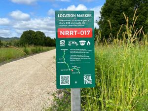
At every kilometre along the trail there is a Location Marker with a unique code. They start with the letters NRRT followed by 3 numbers, which identifies the number of kilometres in distance from the trailhead at Murwillumbah Railway Station.
Read more about emergency information.
Distances: Casino to Lismore
View the Casino to Lismore map
| Old Casino Station | Spring Grove Road carpark | Naughton Gap Road carpark | Barlings Creek Bridge | Naughtons Gap Road Tunnel Overpass | Bentley Road carpark | Back Creek Bridge, Bentley | Oakey Creek Bungabbee Road | Back Creek Bridge, Leycester | Kyogle Road Cubawee | Rifle Range Road | Nesbitt Park Connection | Lismore Railway Station | |
|---|---|---|---|---|---|---|---|---|---|---|---|---|---|
| Old Casino Station | Trail Head | 0.65 km | 1 km | 2.45 km | 7.85 km | 11.85 km | 12.6 km | 15.01 km | 20.81 km | 23.71 km | 25.21 km | 29.21 km | 29.86 km |
| Spring Grove Road carpark | 0.65 km | 0 | 0.35 km | 1.8 km | 7.2 km | 11.2 km | 11.95 km | 14.36 km | 20.16 km | 23.06 km | 24.56 km | 28.56 km | 29.21 km |
| Naughton Gap Road carpark | 1 km | 0.35 km | 0 | 1.45 km | 6.85 km | 10.85 km | 11.6 km | 14.01 km | 19.81 km | 22.71 km | 27.41 km | 28.21 km | 28.86 km |
| Barlings Creek Bridge | 2.45 km | 1.8 km | 1.45 km | 0 | 5.4 km | 9.4 km | 10.15 km | 12.56 km | 18.36 km | 21.26 km | 22.76 km | 26.76 km | 27.41 km |
| Naughtons Gap Road Tunnel Overpass | 7.85 km | 7.2 km | 6.85 km | 5.4 km | 0 | 4 km | 4.75 km | 7.16 km | 12.96 km | 15.86 km | 17.36 km | 21.36 km | 21.04 km |
| Bentley Road carpark | 11.85 km | 11.2 km | 10.85 km | 9.4 km | 4 km | 0 | 0.75 km | 3.16 km | 8.96 km | 11.86 km | 13.36 km | 17.36 km | 18.01 km |
| Back Creek Bridge, Bentley | 12.6 km | 11.95 km | 11.6 km | 10.15 km | 4.75 km | 0.75 | 0 | 2.41 km | 8.21 km | 11.11 km | 12.61 km | 16.61 km | 17.26 km |
| Oakey Creek/Bungabbee Road | 15.01 km | 14.36 km | 14.01 km | 12.56 km | 7.16 km | 3.16 km | 2.41 km | 0 | 5.8 km | 8.7 km | 10.2 km | 14.2 km | 14.85 km |
| Back Creek Bridge, Leycester | 20.81 km | 20.16 km | 19.81 km | 18.36 km | 12.96 km | 8.96 km | 8.21 km | 5.8 km | 0 | 2.5 km | 4.4 km | 8.4 km | 9.05 km |
| Kyogle Road/Cubawee | 23.71 km | 23.06 km | 22.71 km | 21.26 km | 15.86 km | 11.86 km | 11.11 km | 8.7 km | 2.5 km | 0 | 1.5 km | 5.5 km | 6.15 km |
| Rifle Range Road | 25.21 km | 24.56 km | 24.21 km | 22.76 km | 17.36 km | 13.36 km | 12.61 km | 10.2 km | 4.4 km | 1.5 km | 0 | 4 km | 4.65 km |
| Nesbitt Park Connection | 29.21 km | 28.56 km | 28.21 km | 26.76 km | 21.36 km | 17.36 km | 16.61 km | 14.2 km | 8.4 km | 5.5 km | 4 km | 0 | 0.65 km |
| Lismore Railway Station | 29.86 km | 29.21 km | 28.86 km | 27.41 km | 21.04 km | 18.01 km | 17.26 km | 14.85 km | 9.05 km | 6.15 km | 4.65 km | 0.65 km | 0 |
Distances: Murwillumbah to Crabbes Creek
View the Murwillumbah to Crabbes Creek map
| Murwillumbah Railway Station | Tweed Regional Gallery | Stokers Siding Station | Upper Burringbar Station | Burringbar Station | Mooball Station | Crabbes Creek Station | |
|---|---|---|---|---|---|---|---|
| Murwillumbah Railway Station | Trail Head | 2.2 km | 8.3 km | 15.4 km | 18.7 km | 20.85 km | 23.7 km |
| Tweed Regional Gallery | 2.2 km | – | 6.1 km | 13.2 km | 16.5 km | 18.65 km | 21.5 km |
| Stokers Siding Station | 8.3 km | 6.1 km | – | 7.1 km | 10.4 km | 12.55 km | 15.4 km |
| Upper Burringbar Station | 15.4 km | 13.2 km | 7.1 km | – | 3.3 km | 5.45 km | 8.3 km |
| Burringbar Station | 18.7 km | 16.5 km | 10.4 km | 3.3 km | – | 2.15 km | 5.0 km |
| Mooball Station | 20.85 km | 18.65 km | 12.55 km | 5.45 km | 2.15 km | – | 2.85 km |
| Crabbes Creek Station | 23.7 km | 21.5 km | 15.4 km | 8.3 km | 5.0 km | 2.85 km | – |
How long will it take?
Based on averages of:
![]() Walking:
Walking:
5 km/h
![]() Running:
Running:
10 km/h
![]() Riding (leisure):
Riding (leisure):
15 km/h
![]() Riding (enthusiast):
Riding (enthusiast):
25 km/h
Expand the boxes below to see the distances and travel times between the various points. All the distances and times below are based on a one-way journey; for the return journey, simply double the figure. Times are approximate, please use your own judgement and allow additional time for breaks or anything unplanned.
For further information please refer to our frequently asked questions.
- Distance: 2.2 km
- Walk: 27 minutes
- Run: 13 minutes
- Ride (leisure): 9 minutes
- Ride (enthusiast): 5 minutes
- Distance: 6.1 km
- Walk: 1 hour 13 minutes
- Run: 37 minutes
- Ride (leisure): 25 minutes
- Ride (enthusiast): 15 minutes
- Distance: 7.1 km
- Walk: 1 hour 25 minutes
- Run: 43 minutes
- Ride (leisure): 29 minutes
- Ride (enthusiast): 17 minutes
- Distance: 3.3 km
- Walk: 40 minutes
- Run: 20 minutes
- Ride (leisure): 13 minutes
- Ride (enthusiast): 8 minutes
- Distance: 2.15 km
- Walk: 26 minutes
- Run: 13 minutes
- Ride (leisure): 9 minutes
- Ride (enthusiast): 5 minutes
- Distance: 2.85 km
- Walk: 34 minutes
- Run: 17 minutes
- Ride (leisure): 12 minutes
- Ride (enthusiast): 7 minutes